The Sierra de Mijas: an overview
The Sierra de Mijas is a limestone mountain range stretching from Alhaurín de la Torre in the northeast to Marbella in the southwest, spanning approximately 25 kilometres. The highest point is Pico de Mijas at 1,150 metres, but the Calamorro (771 m), Puerto de Málaga (590 m) and Jabalcuza (963 m) are also prominent peaks. The massif forms a natural backdrop to the coastal towns and is a protected natural area with rich biodiversity.
The mountains consist primarily of Jurassic limestone and dolomite, creating spectacular rock formations, caves and gorges. The landscape varies from dense Aleppo pine forests on the northern slopes to bare, esparto-covered limestone plateaus on the southern flanks. Water is scarce in summer, but after rainfall, temporary streams and even waterfalls appear. The Sierra de Mijas is accessible year-round, though the summer months are least suitable due to extreme heat.
Pico de Mijas (1,150 m), the rooftop of the coast
The ascent of Pico de Mijas is the crown jewel route of the mountain range. From Mijas Pueblo, you follow a well-marked trail that takes you via Puerto de Málaga and Loma del Moro to the summit at 1,150 metres. The route is approximately 16 kilometres return with an elevation gain of around 720 metres. Allow 5 to 7 hours for the complete route, depending on your fitness level and the number of breaks.
From the summit, a spectacular 360-degree panorama unfolds: the Mediterranean Sea glistens to the south, the Sierra Nevada mountains are visible to the east, and on clear days you can make out the coast of Africa. The route is at its best in spring and autumn, when temperatures are pleasant and the mountain vegetation turns green. Bring plenty of water (at least 2 litres per person) and start early in the morning to avoid the midday heat.
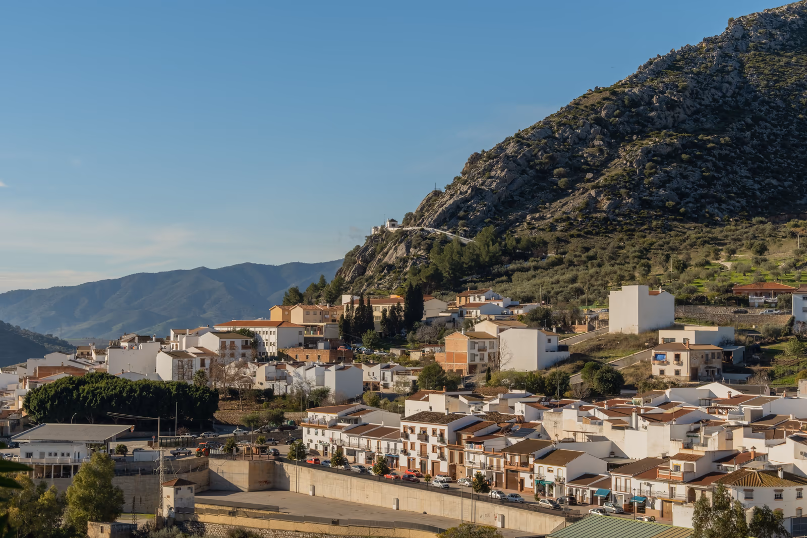
Puerto de Málaga route, the accessible classic
The route to Puerto de Málaga (590 m) is one of the most popular hikes in the Sierra de Mijas and ideal for walkers with average fitness. The path starts from the car park above Mijas Pueblo and follows a wide, well-maintained track along the northern flank of the sierra. The total distance is approximately 10 kilometres return with an elevation gain of about 300 metres, achievable in 3 to 4 hours.
Along the way you pass olive groves, aromatic herb fields and old limestone quarries. At Puerto de Málaga, a mountain pass that traditionally connected Mijas with Alhaurín de la Torre, you're rewarded with beautiful views over both valleys. This is an excellent turning point for a day hike, though ambitious walkers can continue to Pico de Mijas. The route is also popular with mountain bikers, so be mindful of this on busy weekends.
Ermita del Calvario, culture meets nature
The walk to the Ermita del Calvario is the perfect combination of culture and nature, and particularly suited for families and less experienced walkers. The ermita (chapel) sits on a ridge above Mijas Pueblo at approximately 480 metres elevation. The path begins in the village centre and leads you up via a Via Crucis (Way of the Cross) with 14 stations to the chapel. The walk is just 2 kilometres return with a modest elevation gain of 80 metres.
At the chapel you're rewarded with one of the finest views along the coast of Mijas Costa, Fuengirola, and on clear days as far as Málaga. It's a popular spot for watching the sunset. The ermita itself dates from the 17th century and is a pilgrimage site for the local population. Combine this short walk with a visit to Mijas Pueblo, where you can enjoy tapas, artisan shops and the famous donkey museum.
Flora & fauna of the Sierra de Mijas
The Sierra de Mijas harbours a surprisingly rich biodiversity. Vegetation ranges from Mediterranean scrubland (maquis) with rosemary, thyme, lavender and cistus on the lower slopes, to Aleppo pine forests (Pinus halepensis) and dwarf fan palms (Chamaerops humilis) on the mid-slopes. At higher elevations, rock-dwelling herbs and esparto grasses dominate the landscape. In spring, the sierra puts on a spectacular display with wild orchids, peonies and a carpet of yellow and purple flowers.
The fauna is equally impressive. Spanish ibex (Capra pyrenaica hispanica) are regularly spotted on the rocky slopes, keep your camera ready. Birds of prey such as the Bonelli's eagle (Aquila fasciata), Griffon vulture and Common buzzard circle above the ridges. On the ground you may encounter the ocellated lizard, the Moorish tortoise and various snake species. At night, the mountains become the domain of the fox, the stone marten and the rare genet.
What to bring
Good preparation makes the difference between a great hike and an uncomfortable experience. Wear sturdy hiking boots with good ankle support and a treaded sole, the limestone terrain can be slippery and uneven. Dress in layers: mornings can be cool at altitude, while it warms up quickly in the afternoon. A windproof jacket is always wise; even in summer it can be quite windy on the ridges.
Bring at least 2 litres of water per person, there are no water points along the way. A hat, sunscreen (SPF 50+) and good sunglasses are essential due to the intense Andalusian sun. Pack a lunch with energy-rich snacks, a first-aid kit with blister plasters, a fully charged phone with offline maps (Wikiloc or AllTrails), and trekking poles for the steeper descents. In winter, a headlamp is wise in case the return journey takes longer than planned.
Difficulty levels & route selection
The Sierra de Mijas offers routes for every level. For beginners and families, the Ermita del Calvario and the first section of the Puerto de Málaga route are ideal, wide paths, modest elevation gain and always within reach of the village. Intermediate walkers will enjoy the full Puerto de Málaga route or the circular walk via the Calamorro (771 m), accessible by cable car from Benalmádena and then descending on foot to Mijas Pueblo.
Experienced mountain hikers will find their challenge on Pico de Mijas, the full traverse of the massif (Benalmádena-Mijas-Alhaurín, approximately 20 km), or the steep climb via Tajo del Caballo. These routes require good fitness, navigation skills and proper equipment. During the summer months (June-September), only the short routes in the early morning are advisable, temperatures above 35 °C make long mountain treks dangerous. Always check the weather forecast before setting off.
Mountain biking & trail running
The Sierra de Mijas is also a top destination for mountain bikers and trail runners. Wide fire tracks and singletrails form an extensive network suitable for every level. The most popular mountain bike routes run via Puerto de Málaga and Cañada del Lobo, with technical singletracks and spectacular descents. E-mountain bikes are increasingly popular and make it possible to reach the higher zones without peak fitness, several rental shops operate in Mijas Pueblo and Fuengirola.
Trail running is rapidly gaining popularity in the region. The annual CxM Sierra de Mijas trail run attracts hundreds of participants from across Spain. Routes of 10 to 40 kilometres wind across ridges and through valleys, with elevation gains of 500 to 1,500 metres. Autumn and winter months are ideal for trail running, with cooler temperatures and beautiful scenery. Local running groups regularly organise group training sessions, a great way to learn the routes and meet like-minded enthusiasts.
Safety tips & emergencies
Hiking in the Sierra de Mijas is generally safe, but the mountains deserve respect. Never hike alone on remote routes and always let someone know your planned route. Mobile reception is variable, in some valleys you may have no signal. Therefore, always download offline maps and a GPS track before setting off. The Spanish emergency number is 112 and the Guardia Civil mountain rescue team (GREIM) specialises in mountain rescue operations.
Watch out for loose rocks, especially after rainfall when the limestone terrain can be slippery. In summer, heat stress is a real risk, recognise the symptoms (dizziness, nausea, headache) and turn back if you experience them. Snakes are present in the sierra, including the Lataste's viper (Vipera latastei), but encounters are extremely rare if you watch where you step. During hunting season (October-February), it's best to wear bright colours on paths outside the marked hiking routes. Respect nature: take all your rubbish with you and never light open fires.
Frequently asked questions
Spring and autumn (March-May and October-November) are ideal with temperatures around 18-25 °C. Winter is also excellent for hiking. Avoid the summer months due to extreme heat above 35 °C.
The main routes to Puerto de Málaga and Pico de Mijas are reasonably well marked, but not all paths are signposted. We recommend using a GPS app such as Wikiloc or AllTrails with an offline downloaded track.
Yes, the Ermita del Calvario is perfectly suited for families, it's a short, easy walk with beautiful views. The first section of the Puerto de Málaga route is also manageable with older children.
Most routes start at or near Mijas Pueblo, a 15-minute drive from Coral Mijas Stay. There is free parking on the edge of the village. The Calamorro is also accessible via the cable car from Benalmádena.
Yes, several local organisations offer guided hikes, often free or for a small fee. The Mijas Pueblo tourist office has up-to-date information on scheduled group walks.